Puerto Natales: Difference between revisions
Jump to navigation
Jump to search
Content added Content deleted
No edit summary |
|||
| Line 38: | Line 38: | ||
File:Cisne_cuello_negro.jpg |
File:Cisne_cuello_negro.jpg |
||
File:CorMoran_de_las_rocas_G-20210521-WA0005.jpg|[[Cormorán de las Rocas]] |
File:CorMoran_de_las_rocas_G-20210521-WA0005.jpg|[[Cormorán de las Rocas]] |
||
File:Kau_natales_G-20211227-WA0000.jpg |
File:Kau_natales_G-20211227-WA0000.jpg|[[Kau_Río_Serrano_Lodge|Kau]] |
||
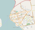
File:Plano de Puerto Natales.png |
File:Plano de Puerto Natales.png |
||
</gallery> |
</gallery> |
||
Revision as of 15:35, 9 May 2022
Coordinates: 51°43′47″S 72°29′55″W / 51.7298°S 72.4986°W
This article is intended to summarize and provide historical context for the many Bluepages articles on individual locations relating to Puerto Natales. For more general information about Puerto Natales, see the Wikipedia article on Puerto Natales. |
A Chilean Patagonia city founded on 1911. With an estimated population of 21,477 in 2019.
Services
-

-

-

rehue
-

Hostal


Leisure
-

-

-

Historical Monument «Feria Franca»


Restaurant Cormorán de las Rocas
Museo Histórico Municipalidad de Puerto Natales
Gallery
-

ancient Hospital at Ignacio Carrera Pinto
-

new facilities Hospital Augusto Essmann B
-

-

-

-