San Francisco Rail station: Difference between revisions
Jump to navigation
Jump to search
Content added Content deleted
No edit summary |
No edit summary |
||
| Line 1: | Line 1: | ||
{{coord|-33.9769| -70.7133}} |
{{coord|-33.9769| -70.7133|display=title}} |
||
{{Infobox building |
{{Infobox building |
||
| name = san Francisco de Mostazal, rail station |
| name = san Francisco de Mostazal, rail station |
||
| Line 24: | Line 24: | ||
[[File:Miraheze_Commons_logo_(proposal).svg|32px]] |
[[File:Miraheze_Commons_logo_(proposal).svg|32px]] |
||
[[commons:san Francisco de Mostazal]] |
[[commons:san Francisco de Mostazal]] |
||
==References== |
|||
<references/> |
<references/> |
||
Revision as of 15:08, 7 February 2021
Coordinates: 33°58′37″S 70°42′48″W / 33.9769°S 70.7133°W
| san Francisco de Mostazal, rail station | |
|---|---|
 | |
| General information | |
| Type | monument |
| Location | Bernardo OHiggins, San Francisco de Mostazal |
| Opened | 2021 |
The original building was declared a national monument in 1981, however, it was closed to the public in 1985 as a result of the damage it suffered in the earthquake of the same year, which worsened after the 2010 earthquake. [1]
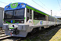
Gallery
-

«Tren central» leaving St.Francisco
-
commuter rail
-

back as seen from the Cultural Center


![]() commons:san Francisco de Mostazal
commons:san Francisco de Mostazal